
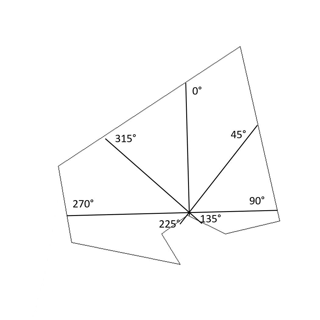
找出距离指定方向的空间点最近的距离
我想为预定的方位(0,45,90,135,185,225,270,315)计算从空间点到空间线(或多边形)的最近距离。
这个想法是为海岸线上的一些海湾计算一个暴露指数。下面是一个简单的例子:
创建线条
library(sp)
coords<-structure(list(lon = c(-6.1468506, -3.7628174, -3.24646,
-3.9605713, -4.4549561, -4.7955322, -4.553833, -5.9710693, -6.1468506),
lat = c(53.884916, 54.807017, 53.46189, 53.363665, 53.507651, 53.363665, 53.126998, 53.298056,53.884916)), class = "data.frame", row.names = c(NA,-9L))
l<-Line(coords)
sl<-SpatialLines(list(Lines(list(l),ID="a")),proj4string=CRS("+init=epsg:4326"))
创建点
pt<-SpatialPoints(coords[5,]+0.02,proj4string=CRS("+init=epsg:4326"))绘图
plot(sl)
plot(pt,add=T)
我很难找到下一步可能是什么,需要帮助的例子。
我想计算的距离的例子
回答 3
Stack Overflow用户
发布于 2019-05-16 08:29:49
谢谢@patL和@Wimpel,我使用了您的建议来解决这个问题。
首先,我使用destPoint::geosphere创建来自原点的设定距离和方位的空间线。然后使用gIntersection::rgeos获取每个横断面与海岸线相交的空间点。最后,利用gDistance::rgeos和子集的最小值,即最近的相交点,分别计算出各断面线的原点到所有相交点的距离。
装载包
pkgs=c("sp","rgeos","geosphere","rgdal") # list packages
lapply(pkgs,require,character.only=T) # load packages
创建数据
海岸线
coords<-structure(list(lon =c(-6.1468506,-3.7628174,-3.24646,
-3.9605713,-4.4549561,-4.7955322,-4.553833,-5.9710693,-6.1468506),
lat=c(53.884916,54.807017,53.46189,53.363665,53.507651,53.363665,53.126998,53.298056,53.884916)), class = "data.frame", row.names = c(NA,-9L))
l=Line(coords)
sl=SpatialLines(list(Lines(list(l),ID="a")),proj4string=CRS("+init=epsg:4326"))
点
sp=SpatialPoints(coords[5,]+0.02,proj4string=CRS("+init=epsg:4326"))
p=coordinates(sp) # needed for destPoint::geosphere
创建横断面线
b=seq(0,315,45) # list bearings

tr=list() # container for transect lines

for(i in 1:length(b)){
    tr[[i]]<-SpatialLines(list(Lines(list(Line(list(rbind(p,destPoint(p=p,b=b[i],d=200000))))),ID="a")),proj4string=CRS("+init=epsg:4326")) # create spatial lines 200km to bearing i from origin
    }
计算距离
minDistance=list() # container for distances


for(j in 1:length(tr)){ # for transect i
    intersects=gIntersection(sl,tr[[j]]) # intersect with coastline
    minDistance[[j]]=min(distGeo(sp,intersects)) # calculate distances and use minimum
}

do.call(rbind,minDistance)
实际上,原点是一个空间点数据帧,对于许多站点,这个过程被循环多次。在执行intersect时,也有许多NULL结果,因此循环包含一个if语句。
Stack Overflow用户
发布于 2019-03-28 09:38:21
您可以使用geosphere库来完成它。不过,您需要在要点中添加一个CRS:
library(geosphere)

pt <- SpatialPoints(c[5,],
proj4string=CRS("+init=epsg:4326")) 然后使用dist2Line函数:
st_distance(st_cast(sl, "POINT"), pt)

#     distance       lon      lat ID
#[1,] 2580.843 -4.451901 53.50677 1或者,您可以使用sf包将多行转换为点,然后获取距离矩阵(您需要将对象转换为sf类):
library(sf)

sl <- SpatialLines(list(Lines(list(l),ID="a")),
                   proj4string=CRS("+init=epsg:4326")) %>%
  st_as_sf()

pt <- SpatialPoints(coords[5,]+0.02,
                    proj4string=CRS("+init=epsg:4326")) %>%
  st_as_sf()

st_distance(st_cast(sl, "POINT"), pt)

#Units: [m]
#            [,1]
# [1,] 119833.165
# [2,] 149014.814
# [3,]  79215.071
# [4,]  36422.390
# [5,]   2591.267
# [6,]  30117.701
# [7,]  45287.637
# [8,] 105289.230
# [9,] 119833.165Stack Overflow用户
发布于 2019-03-28 13:01:23
作为一个提醒:我不是英雄,当谈到地理数据在R。
此外:我还没有自动计算所有轴承,但手动执行操作,以获得距离的相交德45轴承。
你得自己找出循环,因为我没有时间。完成后,可以在这里提供/发布您的最终发现/代码。
这是我对这个问题的解答,一步一步。
#load libraries used
library(geosphere)
library(tidyverse)
library(sf)

#get bearings of lines of the polygon
df.poly <- coords %>%
  mutate( lon_next = lead(lon), lat_next = lead(lat) ) %>%
  mutate( bearing_to_next = ifelse( !is.na( lon_next ),
                                    unlist( pmap( list( a = lon, b = lat, x = lon_next, y = lat_next ),
                                                  ~ round( geosphere::bearing( c(..1, ..2), c(..3, ..4) ) )
                                                  )
                                            ),
                                    NA )
          ) %>%
  filter( !is.na( lon_next ) )

#         lon      lat bearing_to_next
# 1 -6.146851 53.88492              56
# 2 -3.762817 54.80702             167
# 3 -3.246460 53.46189            -103
# 4 -3.960571 53.36366             -64
# 5 -4.454956 53.50765            -125
# 6 -4.795532 53.36366             148
# 7 -4.553833 53.12700             -78
# 8 -5.971069 53.29806             -10

#find intersection point based on the intersection of two 'great circles'
#from two points with a bearing
gcIntersectBearing(
  #coordinates 2nd point of polyline, with bearing to third point
  c( -3.7628174, 54.807017 ), 167,
  #coordinates point, with bearing of 45
  c( -4.454956, 53.50765 ), 45 )

#            lon      lat      lon       lat
# [1,] -3.476074 54.07798 176.5239 -54.07798
让我们看看到目前为止
p_intersect <- data.frame( lon = -3.476074, lat = 54.07798 ) %>%
  st_as_sf( coords = c( "lon", "lat" ), crs = 4326 )

startpoint <- coords %>% slice(5) %>% mutate( lon = lon + 0.02, lat = lat + 0.02 ) %>%
  st_as_sf( coords = c("lon","lat"), crs = 4326 )

poly <- coords %>%
  as.matrix() %>%
  list() %>%
  st_polygon() %>%
  st_sfc() %>%
  st_set_crs( 4326 )

mapview::mapview( list(poly, startpoint, p_intersect) )
从带有45度方位的多边形p_intersect到多边形poly上的交点poly的位置看起来是正确的。
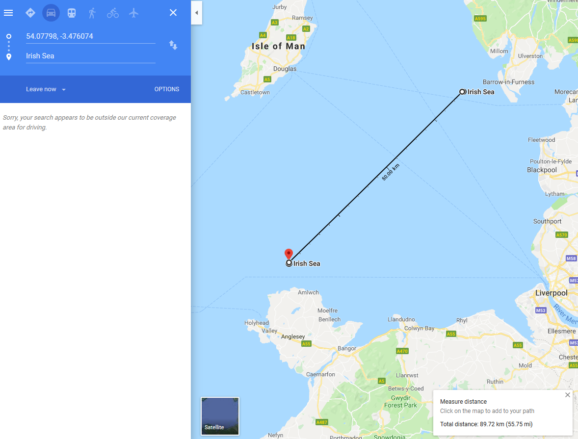
现在,您可以按以下方式计算距离:
#calculate distance
st_distance( startpoint, p_intersect )
# Units: [m]
#         [,1]
# [1,] 87993.3
谷歌地图似乎在距离上达成了一致(在我看来,这有点像鼠标绕点一样,但看上去没问题)
现在你必须想出一些聪明的循环/矢量化,然后你就完成了:)我必须回到我真正的工作上。
https://stackoverflow.com/questions/55393494
复制相似问题
腾讯云开发者

Copyright © 2013 - 2026 Tencent Cloud. All Rights Reserved. 腾讯云 版权所有
深圳市腾讯计算机系统有限公司 ICP备案/许可证号:粤B2-20090059 ![]() 粤公网安备44030502008569号
粤公网安备44030502008569号
腾讯云计算(北京)有限责任公司 京ICP证150476号 | 京ICP备11018762号