
ggplot2地图-创建掩码填充一个不包括单个国家的框
ggplot2地图-创建掩码填充一个不包括单个国家的框
提问于 2017-05-26 20:41:06
是否有可能在of图中有一个图层作为ggmap层的掩码?这里他们在ggmap上添加了一个国家多边形。
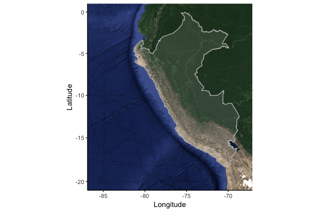
我正在寻找的是,国家将是一个“洞”的一层(阿尔法)覆盖一切,但国家。在某种程度上,上面的例子正好相反。来自该答案的代码(添加透明度并更新为使用geom_cartogram)。
library(mapdata)
library(ggmap)
library(ggplot2)
library(ggalt)

# Get Peru map
Peru <- get_map(location = "Peru", zoom = 5, maptype="satellite")

# This is the layer I wish to put over the top
coast_map <- fortify(map("worldHires", fill = TRUE, plot = FALSE))

# Subset data for Peru
peru.coast <- subset(coast_map, region == "Peru")

# Draw a graphic
ggmap(Peru) +
  geom_cartogram(data = peru.coast, map = peru.coast, aes(x = long, y = lat, map_id = region),
           fill="white", color="grey", alpha=.1) +
  xlim(-86, -68) +
  ylim(-20, 0) +
  labs(x = "Longitude", y = "Latitude") +
  coord_map() +
  theme_classic()
在ggplot2中,除了多边形之外,还有什么方法可以填充所有的东西吗?
回答 1
Stack Overflow用户
回答已采纳
发布于 2017-05-26 22:52:30
在ggplot2中,除了多边形之外,还有什么方法可以填充所有的东西吗?
这种方法可能有点不正统,但无论如何:
library(mapdata)
library(ggmap)
library(ggplot2)
library(raster)
ggmap_rast <- function(map){
  map_bbox <- attr(map, 'bb')
  .extent <- extent(as.numeric(map_bbox[c(2,4,1,3)]))
  my_map <- raster(.extent, nrow= nrow(map), ncol = ncol(map))
  rgb_cols <- setNames(as.data.frame(t(col2rgb(map))), c('red','green','blue'))
  red <- my_map
  values(red) <- rgb_cols[['red']]
  green <- my_map
  values(green) <- rgb_cols[['green']]
  blue <- my_map
  values(blue) <- rgb_cols[['blue']]
  stack(red,green,blue)
}
Peru <- get_map(location = "Peru", zoom = 5, maptype="satellite")
data(wrld_simpl, package = "maptools")
polygonMask <- subset(wrld_simpl, NAME=="Peru")
peru <- ggmap_rast(Peru)
peru_masked <- mask(peru, polygonMask, inverse=T)
peru_masked_df <- data.frame(rasterToPoints(peru_masked))
ggplot(peru_masked_df) +
  geom_point(aes(x=x, y=y, col=rgb(layer.1/255, layer.2/255, layer.3/255))) +
  scale_color_identity() +
  coord_quickmap()
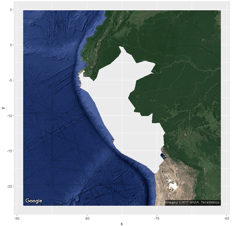
我要找的是透明填充层的环境和alpha=1的秘鲁
如果第一次想到这很容易。然而,后来我看到并记得geom_polygon不太喜欢有洞的多边形。幸运的是,来自包geom_polypath的ggpolypath做了。然而,它将抛出一个“grid.Call.graphics中的错误(L_path,x$x,x$y,index,switch(x$规则,缠绕=1L.)”ggmap的默认面板扩展出现错误。
所以你可以
library(mapdata)
library(ggmap)
library(ggplot2)
library(raster)
library(ggpolypath) ## plot polygons with holes
Peru <- get_map(location = "Peru", zoom = 5, maptype="satellite")
data(wrld_simpl, package = "maptools")
polygonMask <- subset(wrld_simpl, NAME=="Peru")
bb <- unlist(attr(Peru, "bb"))
coords <- cbind(
  bb[c(2,2,4,4)],
  bb[c(1,3,3,1)])
sp <- SpatialPolygons(
  list(Polygons(list(Polygon(coords)), "id")),
  proj4string = CRS(proj4string(polygonMask)))
sp_diff <- erase(sp, polygonMask)
sp_diff_df <- fortify(sp_diff)

ggmap(Peru,extent="normal") +
  geom_polypath(
    aes(long,lat,group=group),
    sp_diff_df,
    fill="white",
    alpha=.7
  )
页面原文内容由Stack Overflow提供。腾讯云小微IT领域专用引擎提供翻译支持
原文链接:
https://stackoverflow.com/questions/44209859
复制相关文章
相似问题
腾讯云开发者

Copyright © 2013 - 2026 Tencent Cloud. All Rights Reserved. 腾讯云 版权所有
深圳市腾讯计算机系统有限公司 ICP备案/许可证号:粤B2-20090059 ![]() 粤公网安备44030502008569号
粤公网安备44030502008569号
腾讯云计算(北京)有限责任公司 京ICP证150476号 | 京ICP备11018762号