
方位角等距投影公式
方位角等距投影公式
提问于 2012-08-14 04:30:59
给定一个位置(lat,lng),我想在方位等距投影中得到它的坐标。这些公式被解释为这里。
下面是网页的截图。
在那一页的末尾,它说
在给定任何位置(lat -Pi/2,+Pi/2,lng [0,+2pi)和投影中心(latCenter,lngCenter)的情况下,我可以计算出它在地图中的坐标(x,y),由于没有提供地图半径,x和y的值将在-1,+1或-Pi,+Pi的范围内。
我的问题是,公式中的c是什么?如果它是从(x,y)中计算出来的值,那么如何使用它来计算(x,y)?
有人能帮我理解这些公式吗?
回答 2
Stack Overflow用户
回答已采纳
发布于 2012-08-14 04:48:05
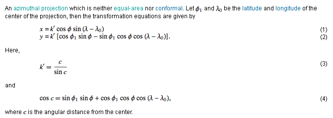
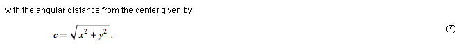
当投影从lat/long到x时,使用等式4计算c,方程7用于计算逆,即从x,y到lat/long。为了你的目的,制作一张地图,忽略等式7。
c是从投影中心(phi0,lambda0)到另一个点(phi,lambda)的大圆弧在地球中心的角。
Stack Overflow用户
发布于 2014-02-10 14:17:30
由于您没有说明您正在使用的编程语言,这里是最近的一个F#中的一个实现。
open System
module AzimuthalEquidistantProjection =

    let inline degToRad d = 0.0174532925199433 * d; // (1.0/180.0 * Math.PI) * d

    let project centerlon centerlat lon lat =
        // http://mathworld.wolfram.com/AzimuthalEquidistantProjection.html
        // http://www.radicalcartography.net/?projectionref
        let t:float = degToRad lat
        let l:float = degToRad lon
        let t1 = degToRad centerlat // latitude center of projection
        let l0 = degToRad centerlon // longitude center of projection
        let c = Math.Acos ((sin t1) * (sin t) + (cos t1) * (cos t) * (cos (l-l0)))
        let k = c / (sin c)
        let x = k * (cos t) * (sin (l-l0))
        let y = k * (cos t1) * (sin t) - (sin t1) * (cos t) * (cos (l-l0))
        (x, y)
其他版本(带有度量单位的F#、Python和Julia)
页面原文内容由Stack Overflow提供。腾讯云小微IT领域专用引擎提供翻译支持
原文链接:
https://stackoverflow.com/questions/11945814
复制相关文章
相似问题
腾讯云开发者

Copyright © 2013 - 2026 Tencent Cloud. All Rights Reserved. 腾讯云 版权所有
深圳市腾讯计算机系统有限公司 ICP备案/许可证号:粤B2-20090059 ![]() 粤公网安备44030502008569号
粤公网安备44030502008569号
腾讯云计算(北京)有限责任公司 京ICP证150476号 | 京ICP备11018762号