
地质工具GeodeticCalculator
有两个点和一个距离,我试着计算方位角,然后重新计算其中一个点。
然而,计算点与原始点的距离大于50米,这是一个较大的误差。
以下是代码:
 public static void main(String[] args) {

 double startLongitude = -5.1085;
 double startLatitude = 40.6682667;
 double endLongitude = -4.000597497067124;
 double endLatitude = 41.49682079962159;
 double distance = 130947.51;

 try {
 CoordinateReferenceSystem crs = CRS.decode("EPSG:4326");
 GeodeticCalculator calculator = new GeodeticCalculator(crs);

 calculator.setStartingGeographicPoint(startLongitude, startLatitude);
 calculator.setDestinationGeographicPoint(endLongitude, endLatitude);
 double azimuth = calculator.getAzimuth();
 System.out.println("Azimuth=" + azimuth);

 calculator = new GeodeticCalculator(crs);
 calculator.setStartingGeographicPoint(startLongitude, startLatitude);
 calculator.setDirection(azimuth, distance);
 Point2D computedEndPoint = calculator.getDestinationGeographicPoint();
 System.out.println("computedEndPoint=" + computedEndPoint);

 calculator = new GeodeticCalculator(crs);
 calculator.setStartingGeographicPoint(endLongitude, endLatitude);
 calculator.setDestinationGeographicPoint(computedEndPoint);
 distance = calculator.getOrthodromicDistance();
 System.out.println("Distance=" + distance);

 } catch (FactoryException e) {
 e.printStackTrace();
 }

}
产出如下:
Azimuth=44.97189638988797 computedEndPoint=Point2D.Double-4.00014170719737,41.49715519864095 Distance=53.17698966547863
我希望computedEndPoint从一开始就与声明的终结点非常相似(如果不是完全相同的话)。这两点之间的距离接近于零。
现在我的问题是:我做错了什么?或者GeodedicCalculator中有什么bug?
回答 1
Stack Overflow用户
发布于 2020-03-01 11:12:49
50米以上130公里是0.04%的误差-这是相当好的往返的迭代数值方法。
你使用的是GeodedicCalculator,它使用地球形状的近似来进行计算。GeoTools使用C.F.Karney,大地测量算法,J. Geodesy 87,43-55 (2013)的GeographicLib实现,解释了用于解决问题的近似方法。
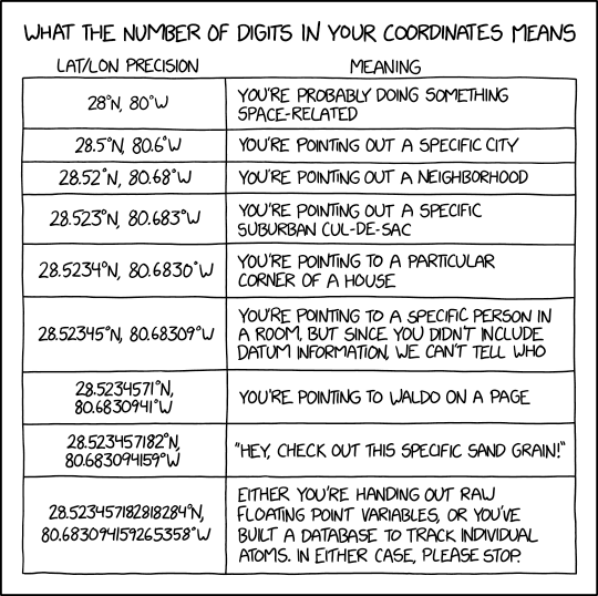
回答 on gis.stackexchange.com解释了在使用纬度和经度时,您可以期望从各种小数位数中得到的精度水平,在本XKCD动画中也对此进行了概述。
你的最低精度点是4DP,所以从其余的计算结果来看,你不能期望超过10米。即使在航空领域,你也不太可能比实际测量的5 DP更好,并且更有可能以3DP和10 s-100米的精度工作。
更新
进一步的调查表明,是你原来的距离值是错误的。
  calculator.setStartingGeographicPoint(startLongitude, startLatitude);
  calculator.setDestinationGeographicPoint(endLongitude, endLatitude);
  double azimuth = calculator.getAzimuth();
  System.out.println("Azimuth=" + azimuth);
  double fullDistance = calculator.getOrthodromicDistance();
  System.out.println("distance " + fullDistance);
  System.out.println("% error " + (Math.abs(fullDistance - distance) / fullDistance) * 100);
  calculator = new GeodeticCalculator(crs);
  calculator.setStartingGeographicPoint(startLongitude, startLatitude);
  calculator.setDirection(azimuth, fullDistance);
  Point2D computedEndPoint = calculator.getDestinationGeographicPoint();
  System.out.println("computedEndPoint=" + computedEndPoint);

  calculator = new GeodeticCalculator(crs);
  calculator.setStartingGeographicPoint(endLongitude, endLatitude);
  calculator.setDestinationGeographicPoint(computedEndPoint);
  distance = calculator.getOrthodromicDistance();
  System.out.println("Distance=" + distance);
  System.out.println("% error " + ((distance / fullDistance) * 100));
给我:
Azimuth=44.971973670068415
distance 130893.86215735915
% error 0.04098575880994952
computedEndPoint=Point2D.Double[-4.000599999999989, 41.49682]
Distance=9.64120596409175E-10
% error 7.365666964965247E-13
如你所见,所有的误差都出现在第一次计算中,正/反行程给出了一个相同的点和9e-10m的距离误差。这对于任何领域都应该是可以的。
https://stackoverflow.com/questions/60456328
复制相似问题
腾讯云开发者

Copyright © 2013 - 2026 Tencent Cloud. All Rights Reserved. 腾讯云 版权所有
深圳市腾讯计算机系统有限公司 ICP备案/许可证号:粤B2-20090059 ![]() 粤公网安备44030502008569号
粤公网安备44030502008569号
腾讯云计算(北京)有限责任公司 京ICP证150476号 | 京ICP备11018762号