
如何从Esri网格(osg)中高效地绘制地形模型?
我有许多Esri文件(https://en.wikipedia.org/wiki/Esri_grid#ASCII),我想在3D中呈现它们,而不会失去精度,我正在使用OpenSceneGraph。
问题是这个网格大约有1000x1000点(或更多)点,所以当我提取顶点,然后计算三角形来创建几何学时,我最终得到了数百万点,并且与场景的交互是不可能的(帧速率降到0)。
我试过几种方法:
- Triangle列表
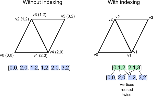
基本上,当我读取文件时,我用每个三角形填充一个包含3个顶点的数组(这将导致复制);
osg::ref_ptr<osg::Geode> l_pGeodeSurface = new osg::Geode;
osg::ref_ptr<osg::Geometry> l_pGeometrySurface = new osg::Geometry;
osg::ref_ptr<osg::Vec3Array> l_pvTrianglePoints = osg::Vec3Array;
osg::ref_ptr<osg::Vec3Array> l_pvOriginalPoints = osg::Vec3Array;

... // Read the file and fill l_pvOriginalPoints

for(*triangle inside the file*)
{
   ... // Compute correct triangle indices (l_iP1, l_iP2, l_iP3)

    // Push triangle vertices inside the array
    l_pvTrianglePoints->push_back(l_pvOriginalPoints->at(l_iP1));
    l_pvTrianglePoints->push_back(l_pvOriginalPoints->at(l_iP2));
    l_pvTrianglePoints->push_back(l_pvOriginalPoints->at(l_iP3));
}

l_pGeometrySurface->setVertexArray(l_pvTrianglePoints);
l_pGeometrySurface->addPrimitiveSet(new osg::DrawArrays(GL_TRIANGLES, 0, 3, l_pvTrianglePoints->size()));- Indexed三角形列表
和以前一样,但是数组只包含每个顶点一次,我创建了第二个索引数组(基本上我告诉osg如何构建三角形,而不是duplication) )。
osg::ref_ptr<osg::Geode> l_pGeodeSurface = new osg::Geode;
osg::ref_ptr<osg::Geometry> l_pGeometrySurface = new osg::Geometry;
osg::ref_ptr<osg::DrawElementsUInt> l_pIndices = new osg::DrawElementsUInt(osg::PrimitiveSet::TRIANGLES, *number of indices*);
osg::ref_ptr<osg::Vec3Array> l_pvOriginalPoints = osg::Vec3Array;

... // Read the file and fill l_pvOriginalPoints

for(i = 0; i < *number of indices*; i++)
{
   ... // Compute correct triangle indices (l_iP1, l_iP2, l_iP3)

    // Push vertices indices inside the array
    l_pIndices->at(i) = l_iP1;
    l_pIndices->at(i+1) = l_iP2;
    l_pIndices->at(i+2) = l_iP3;
}

l_pGeometrySurface->setVertexArray(l_pvOriginalPoints );
l_pGeometrySurface->addPrimitiveSet(l_pIndices.get());
- Instancing
这是一个实验,因为我从来没有使用过着色器,我可以用一个三角形作为实例,然后用变换矩阵(把矩阵作为一个均匀的数组,一个三角形)在我的场景中的每个三角形的顶点着色器中操作它的坐标。最后,我得到了太多的制服,只有一个网格20x20。
我使用这些链接作为参考:
https://learnopengl.com/Advanced-OpenGL/Instancing,
没有一个解决了我的问题,我还能尝试什么呢?在渲染技术方面,我遗漏了什么吗?我以为这任务很简单,但我被困住了。
回答 1
Stack Overflow用户
发布于 2020-07-08 16:38:37
我觉得你应该考虑退一步。如果您正在可视化基于地理信息系统的地形数据,那么osgEarth确实是为实现这一目的而设计的,并且具有相当高效的用于大型地形的LOD工具。您是否需要始终表示为最大全LOD的数据,还是您正在寻找动态LOD来提高帧速率?
根据您的目标和要求,您可能需要考虑一些更先进的地形绘制技术,如右字段跟踪等。如果地形总是静态的,您可以预先计算四叉树和有符号距离函数,并跟踪到高度场。
https://stackoverflow.com/questions/62772372
复制相似问题
腾讯云开发者

Copyright © 2013 - 2026 Tencent Cloud. All Rights Reserved. 腾讯云 版权所有
深圳市腾讯计算机系统有限公司 ICP备案/许可证号:粤B2-20090059  粤公网安备44030502008569号
腾讯云计算(北京)有限责任公司 京ICP证150476号 | 京ICP备11018762号