
形状在更改CCRS后消失。
形状在更改CCRS后消失。
提问于 2021-08-30 09:15:08
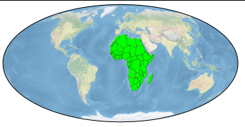
除了another Q&A,我正在绘制地球上的非洲大陆各国的地图:
import cartopy
import cartopy.crs as ccrs
from matplotlib import pyplot as plt

import geopandas as gpd

world = gpd.read_file(gpd.datasets.get_path('naturalearth_lowres'))
africa = world[(world['continent'] == 'Africa')]

latlon_proj = ccrs.PlateCarree()
axis_proj = ccrs.Mollweide()

ax = plt.axes(projection=axis_proj)
ax.stock_img()

for ea in africa['geometry']:

    feat = cartopy.feature.ShapelyFeature(
        [ea],
        latlon_proj,
        facecolor="lime",
        edgecolor='black',
        lw=0.2
        )

    ax.add_feature(feat)

plt.show()
然而,当我把latlon_proj和axis_proj改成ccrs.Orthographic()时,非洲大陆消失了:
import cartopy
import cartopy.crs as ccrs
from matplotlib import pyplot as plt

import geopandas as gpd

world = gpd.read_file(gpd.datasets.get_path('naturalearth_lowres'))
africa = world[(world['continent'] == 'Africa')]

latlon_proj = ccrs.Orthographic()
axis_proj = ccrs.Orthographic()

ax = plt.axes(projection=axis_proj)
ax.stock_img()

for ea in africa['geometry']:

    feat = cartopy.feature.ShapelyFeature(
        [ea],
        latlon_proj,
        facecolor="lime",
        edgecolor='black',
        lw=0.2
        )

    ax.add_feature(feat)

plt.show()
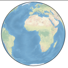
我怎样才能保持非洲大陆在改变CCRS的时候?
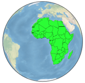
回答 1
Stack Overflow用户
回答已采纳
发布于 2021-08-30 09:20:11
在代码中使用CRS是错误的。这是它的正确版本。
import cartopy
import cartopy.crs as ccrs
from matplotlib import pyplot as plt

import geopandas as gpd

world = gpd.read_file(gpd.datasets.get_path('naturalearth_lowres'))
africa = world[(world['continent'] == 'Africa')]

latlon_proj = ccrs.PlateCarree()  ## The correct CRS
axis_proj = ccrs.Orthographic()

ax = plt.axes(projection=axis_proj)
ax.stock_img()

for ea in africa['geometry']:

    feat = cartopy.feature.ShapelyFeature(
        [ea],
        latlon_proj,
        facecolor="lime",
        edgecolor='black',
        lw=0.2
        )

    ax.add_feature(feat)

plt.show()
页面原文内容由Stack Overflow提供。腾讯云小微IT领域专用引擎提供翻译支持
原文链接:
https://stackoverflow.com/questions/68981605
复制相关文章
相似问题
腾讯云开发者

Copyright © 2013 - 2026 Tencent Cloud. All Rights Reserved. 腾讯云 版权所有
深圳市腾讯计算机系统有限公司 ICP备案/许可证号:粤B2-20090059 ![]() 粤公网安备44030502008569号
粤公网安备44030502008569号
腾讯云计算(北京)有限责任公司 京ICP证150476号 | 京ICP备11018762号